Hike: Mt. Black prince / Mt. Warspite: Kananaskis, Alberta, Canada
Quick Summary
Difficulty: easy (interpretive trail), Moderate to upper valley,
and a easy scramble to the ridge
Distance: 4 km to upper vally, 4.5 to ridge
Elevation gain: 750m
Time Taken: 5.5 hrs, going slow, but only with
short breaks
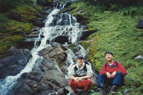
Cool points: Comming into the upper Vally was breath taking.
(Ben liked the warspite cascades the best)
What it's Not: A well travelled trail. (after the interpretive
trail that is.)
Date of Hike: Sept 11, 1999
Recommendations: This is Bear Contry, prepare accordingly.
Notes: The trail head is the same as for the Black
Prince interpretive trail.
Hiking Partners: Carol (novice - 5th hike) Still quite timid,
especially when going down steep inclines.
Ben (novice - 10th hikes(?)) Also quite timid,
very cautious about his capabilities, and
afraid of heights.
Both made it to the upper vally past
the cascade, but not to the ridge.
|
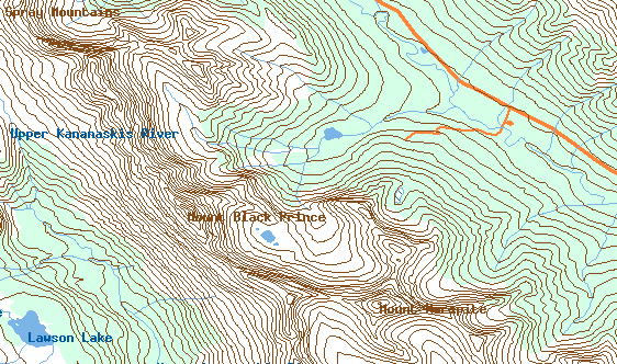
"Map is © Her Majesty the Queen in Right of Canada,
Department of Natural Resources. All rights reserved."
map from the website
http://toporama.cits.rncan.gc.ca/toporama_en.html
|
How to get to the trail head
Travelling West from Calgary on Hwy 1, turn South on Hwy 40 (the
Kananassi Trail), turn right onto the Kananaskis Lakes Trail, and then
right onto the Smith-Doprien/Spray Trail (Hwy 742). Turn to the left
at the sign indicating the Black-Prince day use area, follow this to the
parking area for the trail head.
Ramble on about the hike
This hike starts out along the Black Prince interpretive trail, you can
pick up a brochure for reading at various marked points on the hike. This
will explain some of the different scenery along interpretive trail portion
of the hike.
The trail quickly crosses the Old Creek, a medium sized creek via
a wooden bridge. It is obvious that the interpretive portion of the
trail is well travelled, it is nothing like the 'real' part of the
hike which seems to be very rarely used. My estimate is that around
50 people a year endup in the upper valley between Mt. Warspite and
the Black Prince Mountain. after the bridge the trail continues up
along what was once a loggin road in the 1970s, this initial start
of the trail is a steady climb at about a 20 degree incline for
300m or so. At the top of this little climb, there is a a wooden
bench to take a break at, after this point the trail leaves the
loggin road and continues, at first down wards, and then at a more
or less level elevation around the interpretive loop.
The loop it self follows through the trees, you can see lots of wild
mushrooms, wild flower (at least when we were there) and the like. The
trees are mostly Spruce and Fir trees. The trail heads West, there is
a branch in the trail, if you follow the sign (as we did) you will be
staying on the straiter path (to the right). On the trail watch your footing,
not for dangerous roots, and craggy rocks, but rather for Elk poop (my car
stunk a bit on the drive home because Ben was not paying attention to
where he was planing his feet)
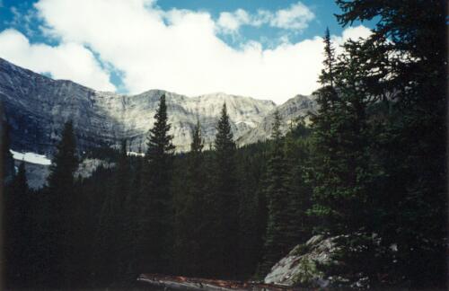
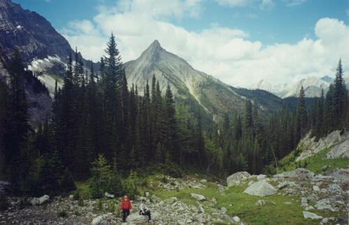
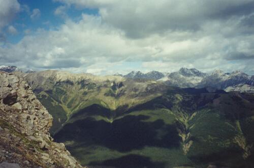
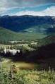
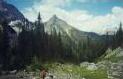
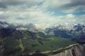
The trail then starts to loop to the south just as you come to the first
good views of Mt. Warspite, Black Prince Mtn, and the others
to the west seen below.
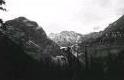
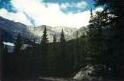
Just past the point where these pictures were taken, the trail comes
to the Warspite lake, this lake
was quite low when we were there, you could see elk tracks leading down to
the water. It is at the lake that the much less travelled trail begins,
the trail itself loops aound the lake to the North side of the lake, you
will want to head off the trail some where between the interpretive sign
post number 8, and number 10. Follow the trail around the north side
of the lake and continue to the south west of the lake. You may have
to cross a stream or two, as I said the lake was obviously low when we
were there yet we had to cross small streams from a light snow fall
the prevous night, I wonder what the stream would be like in the late
spring?
For us, we did not find the trail right away, we crossed through the
dried up portion of the lake, I do not know if there are fish in the
lake, but waking across the dried alge sure gave a smell of fish. Once
we were on the west side of the lake, we found the trial just up and in
the trees. The trail runs through the trees to the south west, but not for
long. soon you come into a medow running down from black prince mountain,
hear the trail splits and branches in a few places, but heads more or less
south. In this field you no longer feel like you are out for a walk on an
tame interpretive trail, I felt like I was now out in the middle of the
wilds. The trail continues south, but branches and splits, as it follows
to the left of a slow meandering stream.
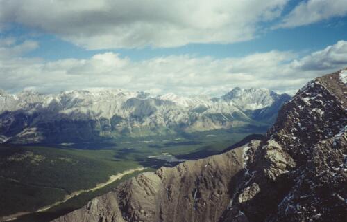
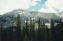
This section of the hike gives a good view of the Warsprite mountain, the
black prince mountain,and a third peak to the north. Following the
trail as it splits and re-joins, after about a 100m or so, it comes to
a wash out of a stream/rock slide. Here the trail is a bit hard to follow,
there are small tarins marking the way, just keep going in the direction
of the trail. These rocks are a bit odd, there is little or no dirt, just
bolders, They are not broken pieces of granite, but rather weathered stones
all more or less a foot in diameter, this rock slide is about
10 ft thick or
so. This makes it a bit tricky with where you plant your
feet to avoid haveing a rock slide out or roll under the feet,
it makes for a slow down in the hike, but I always find it fun
going from rock to rock.
After the rocks we had a bit of trouble finding the trail again, again
there are tairn marking the way. Simply work out of another stand
of trees, and you will come to a 2nd field, this one going up the side
of the mountain. On the Left hand side (West) of the field there is
a gulch (well, it was dry when we were there) The trail continues
along the stream bed. In fact no doubt alot of people walk up the
stream bed it self. Following this, is the first time that you begin
to gain some elevation (other than the very frirst section of the
interpretive trail). The stream vears to the left and up the side
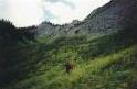
of Black prince mountain, however the trail continues up to the
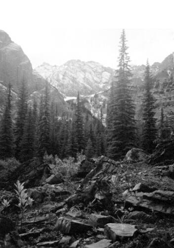
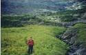
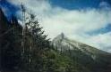
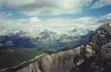
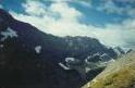
upper valley between the mountains. It is here that The next pictures
are taken, one looking back the way we came, and the other two looking
forward.
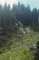
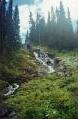
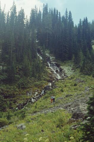
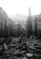
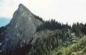
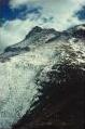
The trail continues along the field, making back towards the
stream, but no longer is it a lazy meandering stream, rather
you come back to the The Warspite Cascades, seen in the picture
to the left. the trail continues up the, heading for the upper
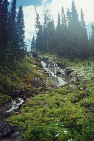
valley to the right of the cascades. Here the trail is actually
quite steep, makeing for very slow progress for our group. It had
snowed up here the night before, now mostly melted, but leaving the
trail very slick. near the top of this steep section of the trail,
there is a fork to the left which you can follow to look at the
cascades from near the drop off. The right side of the fork in the
trail continues into the valley.
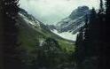
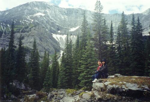
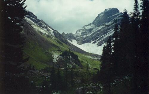
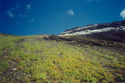
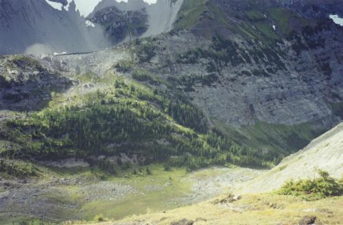
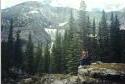
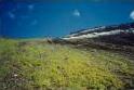
It was walking into the upper valley, that took my breath, it is
truly beautiful. what made it breath taking was that you come out of
the trees at the top of the cascade, and the entire vally is realed at
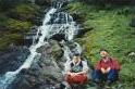
once. We followed into the valley about 50m and stopped for lunch.
Well, my hikking partners were pooped, and decied that they did not
want to go on for fear of over exsertion, We followed into the valley about 50m and stopped for lunch.
Well, my hikking partners were pooped, and decied that they did not
want to go on for fear of over exsertion. I had other plans.
The trail in the book, 'The Kananaskis country trail guide - Gillean Daffern',
is for the Black prince Mtn hike, it will continue strait ahead (the trail
is now nearly non-existant) and then vear to the right and up to 3 lakes
higher on Black prince mountain. I chose rather to go to the right, my
goal was to reach the ridge between Mt Black prince, and Warspite mountain,
with the hope of following the ridge up to the peak of Warspite. My main
consern was (as usual) time, it was now 3:30, like a complete idiot, I
did not bring a watch and did not get one from Ben to continue my treck.
So off I set.
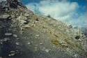
I crossed the valley very quicky, maybe 3 mintues, and then begain to
scramble up the side of the mountain, I was stomping the grass and plants
of the upper medow, which became a combination of loose dirt and shale
as I continued up one side, with grass up the other. I was forced to
stick to the shale, as the grass was very slippery. I would have done
this anyways, as I would prefer not to be crushing the upper elevation
plant life, they have a hard enough time of it as it is. It was here
that I realized just how much this truly was Grizzly country. there was
lost of fairly fresh bear signs, what looked to be fresh digs in the
side of the hill, the were still damp, but it could have just been the
recent snow again. Still it put me on edge, and every time a rock
came careening down from above (which happend about 4 times) it made me
just a little nervous thinking that it could be from a big old bear up
there. It also made me nervious for the two I had left behind in the
valley bellow.
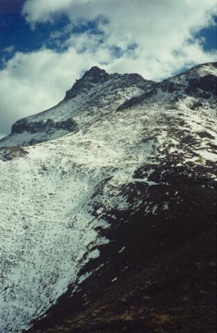
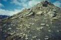
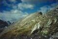
Huffing and puffing, I made it to the ridge, and as always I was
happy that I did, there was a pretty incredible view from up here.
Now thouse who have read other hikes will know I am a little bit afraid
of heights. Kinda dumb, but every time I come to a cliff, it takes a
bit of 'hanging' around before I can feel comfortable. Unfortunately
I was pressed for time. It had taken me about 45minutes to get to the
ridge in my estimate, and I knew that Carol and Ben were pretty slow
in decending, especially steep sections of the trail. So I ended up
following the ridge towards Mt. Warspite, but decided that I best turn
back. So I snapped a wack of pictures and headed down.
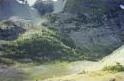
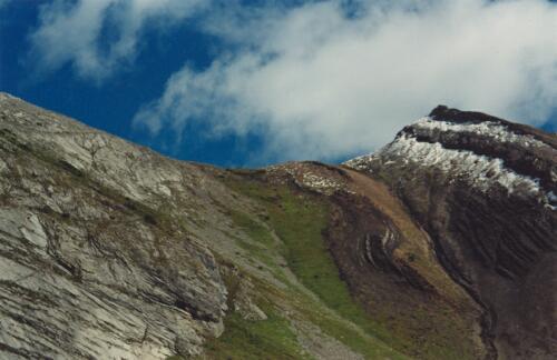
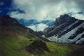
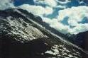
To the left and right are the pictures looking back down to where
Ben and Carol are
from. This picture gives a better Idea of how steep the trip up was.
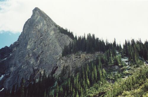
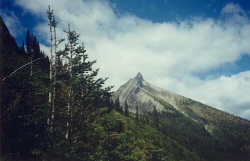
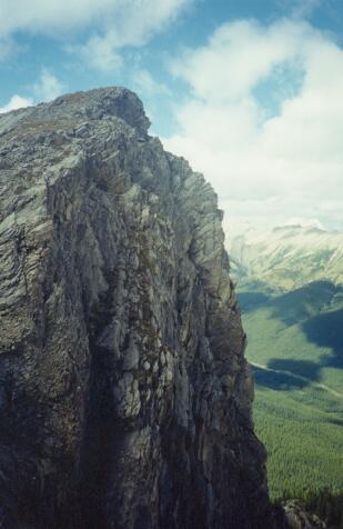
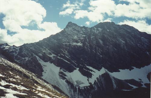
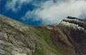
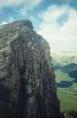
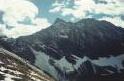
Below is a picture of the first peak on Mt. Warsprite. And then the
main peak main peak. It
is to the top of first peak that I had hoped to make it. This is not
the actual top of Warspite. The picture is looking North from where
I am, and is showing the 'back side' from where Carol and Ben are.
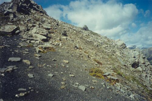
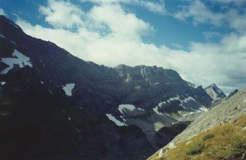
Some pictures of the view off to the East from the ridge

Some pictures of the view off to the West from the ridge
Well the trip down to the upper valley was very fast, using the loose
shale/dirt I made it down in about 7 minutes. As it turned out
the trip up only took about 30minutes, so I had a fair bit of time
to go to the top of the peak. It would have been great! But I think
that nerves played a bit in my decision to come down, it did not
help going up thinking of just how fast and powerfull a Grizily bear
is. Then at the top, the shear cliff which oppened below Mt. Warspite
made me 'wig out' a bit. Ahh, if only Robert of Richard had been with
me, we would have some spectacular pictures from the top, But reaching
the upper valley and then the ridge make this a hike well worth taking.
[an error occurred while processing this directive]