Hike: Grotto Canon, Kananaskis AB, Canada.
Quick Summary
Difficulty: Easy
Distance: 5-8 Km
Elevation gain:Small
Time Taken: 3-4 hrs
Cool points: Indian Pictographs (don't touch!),
Cave in a large 'Hoodo'
What it's Not: A hike to get away from people
Date of Hike: Summer 1998
Recommendations:Water proof boots recomended, or spare
shoes/socks for after hike
Notes: Lots of people, hikers and climbers on this
trail.
|
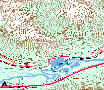
"Map is © Her Majesty the Queen in Right of Canada,
Department of Natural Resources. All rights reserved."
map from the website http://toporama.cits.rncan.gc.ca/toporama_en.html
|
How to get to the trail head
From Calgary there are Two ways to get there, the fastest way is
to follow Hwy 1 West to Canmore (or just before) and turn North onto
Hwy 1A, Follow 1A for around 8km. The trial head is just off the north
side of the highway.
The second more scenic route is to turn off Hwy 1, and go though Morley,
and then follow Hwy 1A South/East to the trail head.
Ramble on about the hike
Twice I have made this hike (in the same year no less) due to following,
the plans of others. The first time was with three friends, the second time
was with a fairly large group of my girlfriend's friends. On the first
trip, we were hiking in the rain most of the time, but the second trip
was beautiful weather.
The trial initially follows Hwy 1A for a short period until you come
to the base of the Grotto canyon. There is a creek following out of the
canon. On the first excursion up this hike, the creek was actually quite
large and fast, it was easy enough to go up the canon, but not really
easy to keep the feet dry. The creek was probably higher than normal due
to snow runoff and the day long drizzle. At the trail head the 'canon'
is quite small, but quite cut into the hill, as you progress the walls
quickly get higher and higher. It is not to far into the hike that you
should see the first set of Indian pictographs. These are quite interesting
but please do not touch, as the oil from you hands will cause the paintings
to deteriorate. On my first trip I was with my good friend
Robert who is a member of the Stoney Indian tribe, needless to say he
was very interested in the pictures, and also quite upset at the condition
of some of them.
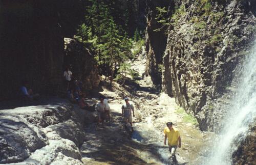
After about 4 km of stomping through the canon, with the babbling brook
beside you you come to a 'Y' in the creek, it is a short 'scramble' up the
right side of the creek to get a view of the falls. The first time we
took this hike we did not go up to the right (the rocks were very slippery
due to the rain), but on the second attempt our group of about 12 scrambled
up the trial, joining the other dozen or so people that were already there.
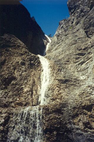
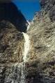
The falls them selves no longer come strait down the valley, the actually
come down the side of the valley (at the end) so you have a bit of a slippery
scramble to actually get to see the main portion of the falls.
Of my group (all non experienced hikers) I was the only one who actually
got to the base of the falls to get the picture you see here. The picture is
looking up at a pretty step angle.

Remember all you new hikers, just because you can scramble up a slippery
incline, it will be harder getting down. Like I said I was with a bunch
of novice hikers, it took a lot longer going down the 30m or so to get to
the fork in the river than going up. Once down on the main trail again
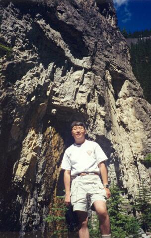
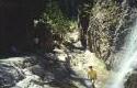
you go back off to the west, at this point you are in some really deep
canon walls. You can see in the second picture Bengerman standing in front
of one of the walls. Shortly after this point the trail veers to the
north once again, and opens up into a valley. It is in this valley that
two of our hikers dropped out of the hike, one had developed blisters
due to wearing new boots, and the other decided to stay and keep her
company. The rest of us wanted to make it to the cave which was a short
distance off (about 20 minutes). Because it was such a large group and
someone was willing to stay with the wounded I did not feel to bad about
'ditching' them for the short term. Normally a entire small group should
turn back.
It is a easy hike up to the base of the Hoodo that contains the canon,
the a short steep climb to the level of the Hoodo. From there it is
a pretty steep (and potentially dangerous) traverse across about 30m
to the cave itself. Once again the
entire group did not make it to the cave (on the second trip) only
5 of us made it into the cave, and it was a pretty scary trip for
3 of them.
The hike out was slow due to the girl who had the blisters, but still
pretty enjoyable for the rest. All along the cave walls you see the
climbing rings from the climbers climbing the walls. I am sure that
we saw 4 or 5 different groups of climbers that weekend.
Lessons Learned on this trip.
Maybe relearned would be a better title, Don't wear unbroken in hiking
boots on a hike, break them in by wearing them around for a week or so.
Remember a slightly uncomfortable boot after an hour of walking in the
mall can become crippling in a long hike. The girl on this hike was in
considerable pain after 4 hours or so. On a previous three day hike
(the rock wall) a friend of mine ended up with blood soaked socks from
multiple broken blood bilisters, on the first day!!, luckily on that hike
he was able to walk out of on of the out trials.
[an error occurred while processing this directive]